Mount Tsukuba Cherry Blossom Famous Spots & Viewing Guide
List of Cherry Blossom Famous Spots & Viewing Spots on Mount Tsukuba: 15 locations
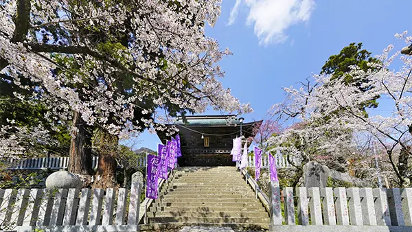
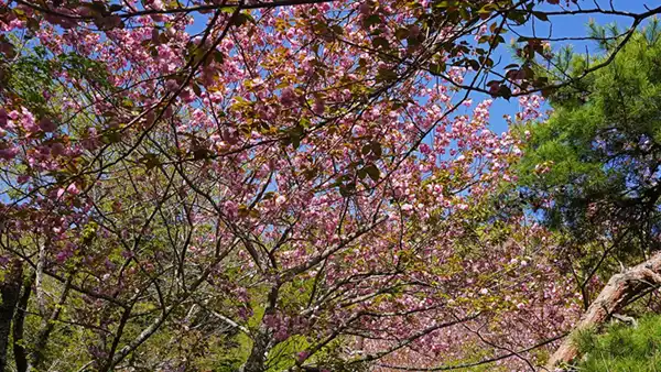
Cherry Blossoms in Tsukubasan Shrine Grounds
 Approach path, around Miyawaki Station of the cable car, Somei Yoshino, Yamazakura, Weeping Cherry Blossoms
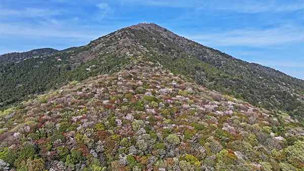
Cluster of Wild Cherry Trees on the South Side of Mt. Tsukuba Nantai Peak
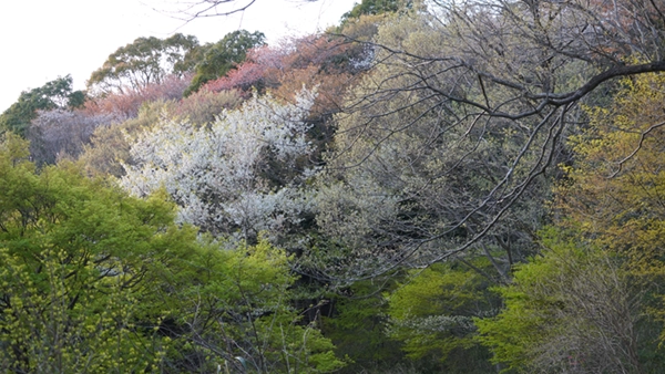
 Cluster of wild cherry trees, Four Seasons Path of Mount Tsukuba
Cherry Blossoms at Tsukuba Plum Grove
 Yamazakura, Weeping Cherry Blossoms, Somei Yoshino
Wild Cherry Blossoms of Sakurayama in Mount Tsukuba
 Kasama Tsukuba Line, Wild Cherry Blossoms
Double Cherry Blossoms of Sakurayama in Mount Tsukuba
 Monument 'Famous Spot Sakurayama', Wild Cherry Blossoms, Double Cherry Blossoms
Kawazu Cherry Blossoms at Tsukuba Fureai no Sato
 Mid to late March, mid-slope of Mt. Tsukuba, Link to Ibaraki Prefecture's Kawazu Cherry Blossom Information Page
Double Cherry Blossoms at Kazekaeshi Pass in Mount Tsukuba
 Omote Tsukuba Skyline, Double Cherry Blossoms
Wild Cherry Blossoms near Kosazuke Jizo
 Omote Tsukuba Skyline, Wild Cherry Blossoms
Weeping Cherry Blossoms in Usui Area of Mount Tsukuba
 4 Weeping Cherry Trees, Rokushodai-butsu
Cherry Blossoms at Hojo Oike Pond
 Tsukuba foothills, approx. 250 Somei Yoshino trees, scenery of Mount Tsukuba
Cherry Blossoms at Rinrin Road Tsukuba Rest Area
 Cycling road rest area, cherry blossom avenue
Rinrin Road: Hojo Cherry Blossom Avenue
 Towards Mount Tsukuba / Former Tsukuba Railway Course, Somei Yoshino
Rinrin Road: Oda Weeping Cherry Blossoms
 Oda Rest Area (Oda Castle Ruins Historical Plaza Information Center), Weeping Cherry Blossom-lined Path
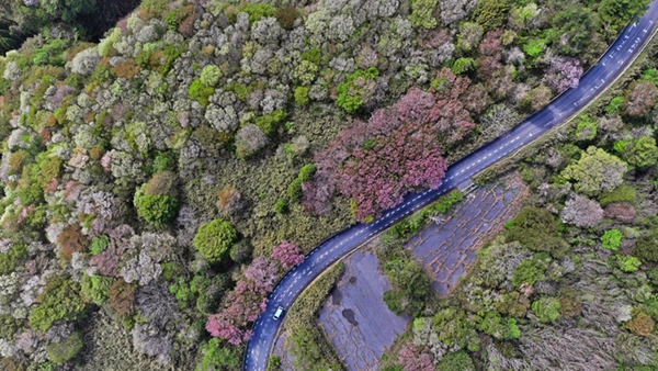
Mountain Cherry Blossoms at Fudo Pass in the Tsukuba Mountains
 Ishioka-Tsukuba Line, Fudo Pass, Mountain Cherry Blossoms
Cherry Blossoms of Mount Hōkyō in the Tsukuba Mountains
 Tsukuba Mountains, Mount Hōkyō, Mountain Cherry Blossoms
Weeping Cherry Blossoms at Oda Rest Area on Tsukuba Rinrin Road
Recommended VR Tour Map of Cherry Blossom Spots on Mount Tsukuba
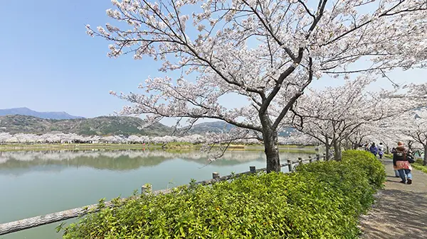
Cherry Blossoms at Tsukubasan Shrine: Mount Tsukuba's Cherry Blossom Viewing Spot
Print
Share
Map of Tsukubasan Shrine
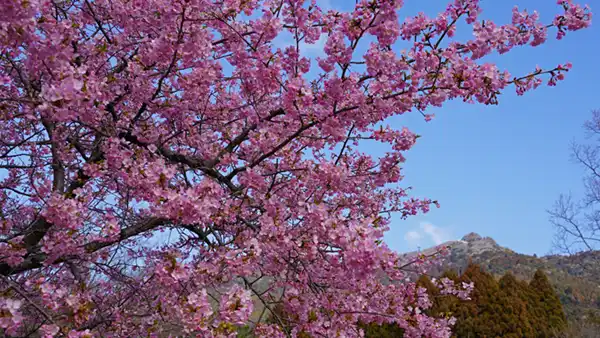
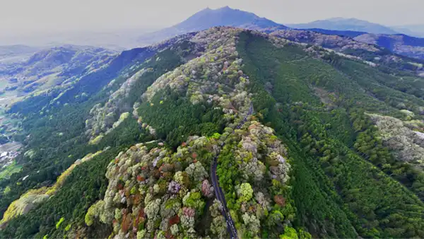
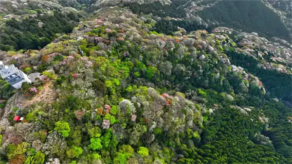
Mountain Cherry Blossom Colony on the Southern Slope of Mount Tsukuba / Mount Nantai
Print
Share
Scenery of Yamazakura on Mt. Tsukuba Shikinomichi and VR Tour Description
Map of the Yamazakura Cluster on Mt. Nantai
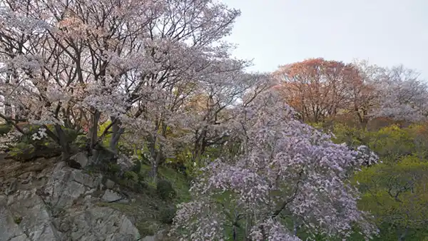
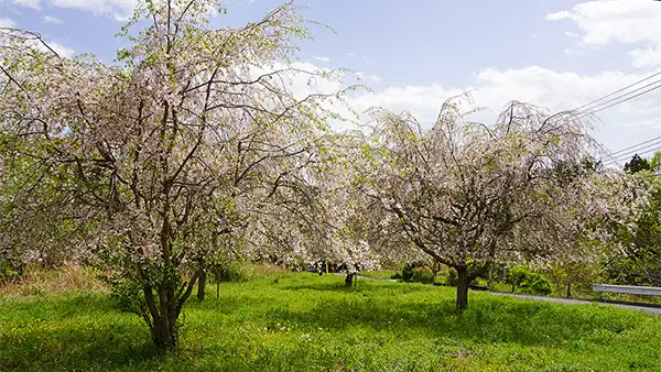
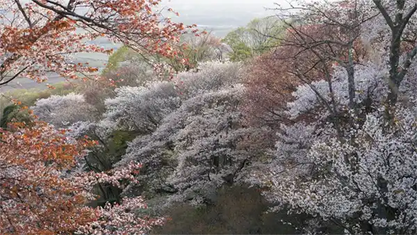
Cherry Blossoms at Mt. Tsukuba Plum Grove
Print
Share

Yamazakura Scenery from the Observation Azumaya Parking Lot
Map of Mountain Cherry Blossom Spots in Mt. Tsukuba Plum Grove
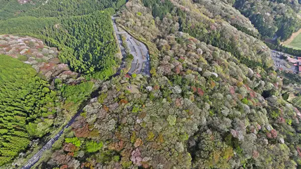
Mountain Cherry Blossoms on Kasama-Tsukuba Line Near Sakurayama, Mt. Tsukuba
Print
Share
Ground View of Mountain Cherry Blossoms on Kasama-Tsukuba Line Near Sakurayama
Location of Mountain Cherry Blossoms on Kasama-Tsukuba Line Near Sakurayama
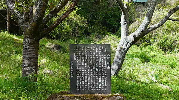
Mt. Tsukuba/Sakurayama Cherry Blossom Famous Spot Monument and Yaezakura, etc.
Print
Share
Sakurayama Double Cherry Blossom Blooming Scene
Location of the "Sakurayama Scenic Spot" Monument
Double Cherry Blossoms South of Kazakaeshi Pass and Mt. Tsukuba Landscape
Print
Share
Aerial View of Omote-Tsukuba Skyline Double Cherry Blossoms and VR Tour Explanation
Map of Yaezakura near Fukaeshi Pass South Side
Yamazakura on the west side of Omote-Tsukuba Skyline near Kosazuke Jizo
Print
Share
Map of Omote-Tsukuba Skyline / Kosazuke Jizo Area
Weeping Cherry Blossoms in Usui Area of Mount Tsukuba
Print
Share
Aerial View and VR Tour Explanation of Weeping Cherry Blossoms in Usui Area
Map of Weeping Cherry Blossoms near Usui Area
Hojo Oike Pond Cherry Blossoms: A Cherry Blossom Viewing Spot at the Foot of Mt. Tsukuba
Print
Share
Hojo Oike Pond Cherry Blossom Blooming Scenery and VR Tour Explanation
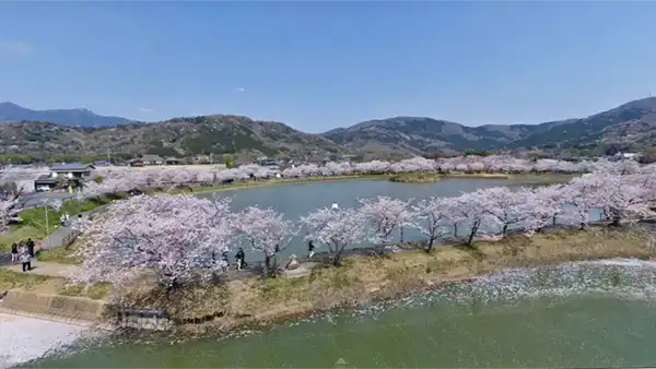
Map of Hojo Oike Pond
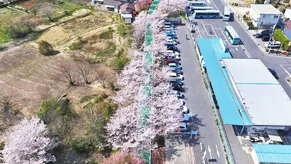
Cherry Blossom Avenue at Rinrin Road Tsukuba Rest Area
Print
Share
Ground-level Cherry Blossom Avenue Scenery and VR Tour Explanation of Rinrin Road Tsukuba Rest Area
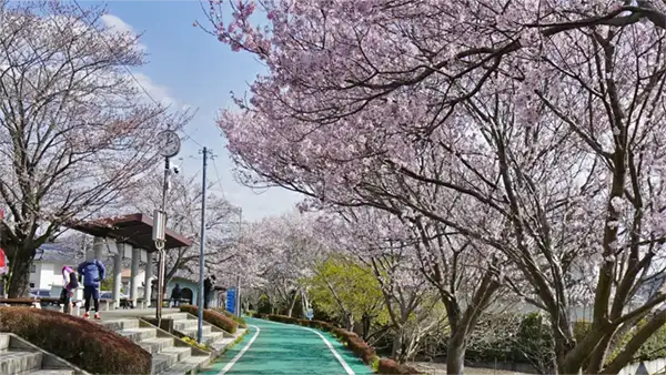
Map of Rinrin Road Tsukuba Rest Area
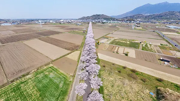
Cherry Blossom Avenue on Rinrin Road: A Famous Cherry Blossom Viewing Spot at the Foot of Mt. Tsukuba
Print
Share
Explanation of Cherry Blossom Tunnel Landscape and VR Tour on the Ground

Map of Tsukuba Rinrin Road Hojo Area Cherry Blossom Avenue
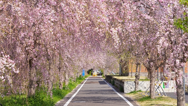
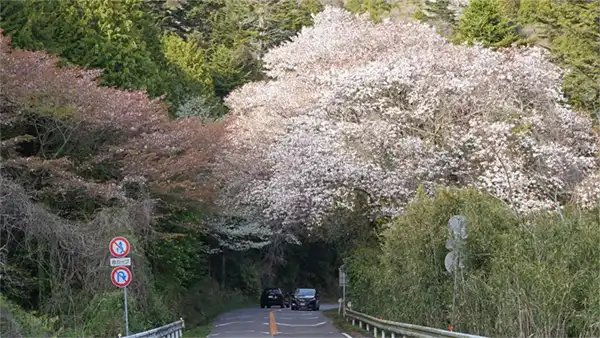
Weeping Cherry Blossom Avenue at Tsukuba Rinrin Road Oda Rest Area: A Famous Cherry Blossom Spot at the Foot of Mt. Tsukuba
Print
Share

Weeping cherry trees are planted like a tree-lined street on both sides along approximately 150 meters of the Oda Rest Area on Tsukuba Rinrin Road.
When the weeping cherry trees are in full bloom, they form a magnificent tunnel, attracting many visitors for photography.
Location〒300-4223 2532-2 Oda, Tsukuba City, Ibaraki Prefecture
ContactOda Castle Ruins Historical Plaza Information Center: Phone 0298-67-4070
Description of the Weeping Cherry Blossom VR Tour at Oda Rest Area on Tsukuba Rinrin Road
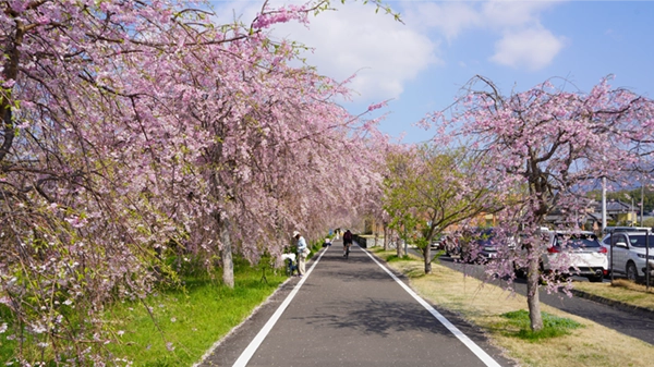
Map of Oda Rest Area on Tsukuba Rinrin Road
Wild Cherry Blossoms at Fudo Pass in the Tsukuba Mountains
Print
Share
Aerial Landscape Photo of the Area Near Fudo Pass and Prefectural Road Ishioka-Tsukuba Line
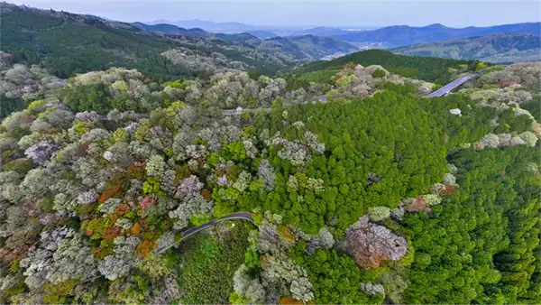
Aerial Map of Fudo Pass
Mt. Hōkyō Cherry Blossoms: A Famous Cherry Blossom Viewing Spot in the Tsukuba Mountains
Print
Share
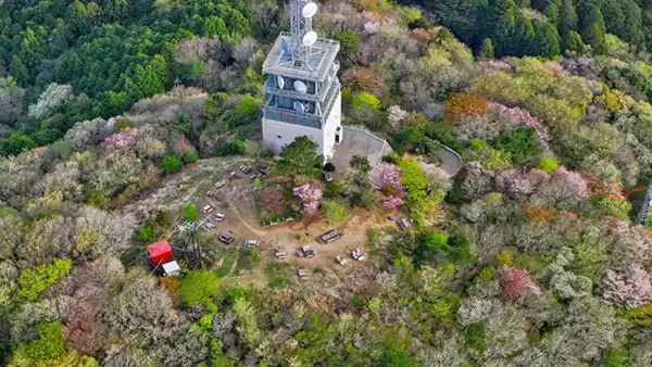
Mountain Cherry Blossom Scenery on the South and West Sides from the Summit Direction
This page currently provides information on the Tsukuba City side of Mount Tsukuba. Additional coverage for the Mount Tsukuba foothills in Sakuragawa City and Ishioka City is planned for the future.